
Understanding GPR Utility Surveys PAS128 London
In the bustling urban landscape of London, accurately locating and mapping underground utilities has become paramount for construction, excavation, and development projects. Ground Penetrating Radar (GPR) technology plays a critical role in achieving this goal. Specifically, the PAS128 standard offers a framework that ensures the integrity and reliability of such surveys. When exploring options, GPR Utility Surveys PAS128 London provides comprehensive insights to avoid costly mishaps and enhance site safety.
What is a GPR Utility Survey?
A GPR Utility Survey is a non-destructive method employed to investigate the presence and condition of buried utilities. Using radar pulses, GPR can penetrate various materials—including soil, asphalt, and concrete—to detect anomalies that signify the location of utilities like water pipes, gas lines, and electrical cables. This method not only uncovers the existence of such utilities but also provides crucial information regarding their depth and composition.
Importance of PAS128 Compliance
PAS128, or Publicly Available Specification 128, is a crucial standard established by the British Standards Institution (BSI). It dictates the protocol for utility surveys, ensuring a systematic approach to the detection and mapping of underground utilities. Compliance with PAS128 is vital for several reasons:
- Risk Mitigation: Following PAS128 guidelines significantly reduces the risk of utility strikes during excavation, which can lead to expensive damages, legal implications, and jeopardised worker safety.
- Regulatory Compliance: Many construction projects require adherence to PAS128 standards to meet local regulations and standards, thereby ensuring lawful operations.
- Enhanced Accuracy: Surveys conducted under the PAS128 framework are more thorough, offering detailed mappings that are essential for effective planning and execution of construction projects.
Key Benefits of GPR Technology in Utility Mapping
The utilisation of GPR technology in utility mapping has transformed how surveyors approach projects. Some key benefits include:
- Non-Destructive Testing: GPR is non-invasive, allowing for the detection of underground utilities without the need for excavation, thus preserving site integrity.
- Real-Time Data Collection: GPR systems provide real-time imaging of subsurface utilities, enabling surveyors to make immediate decisions based on the data gathered.
- Comprehensive Data Analysis: The ability to identify various subsurface structures facilitates a thorough analysis, which is beneficial for long-term planning and development.
Steps Involved in GPR Utility Surveys
Initial Desktop Study Procedures
Before embarking on a GPR survey, an initial desktop study is essential. This involves collating existing records such as utility drawings, historical maps, and any relevant documentation associated with the site. This stage helps surveyors to identify potential utility locations and determine the types of utilities that may be present.
Site Reconnaissance Techniques
Site reconnaissance is the next step in the GPR utility survey process. Surveyors conduct a physical visit to the site to observe visible indicators of underground utilities, such as manholes, drainage covers, and above-ground utility cabinets. This preliminary assessment aids in formulating a more targeted approach for the GPR survey.
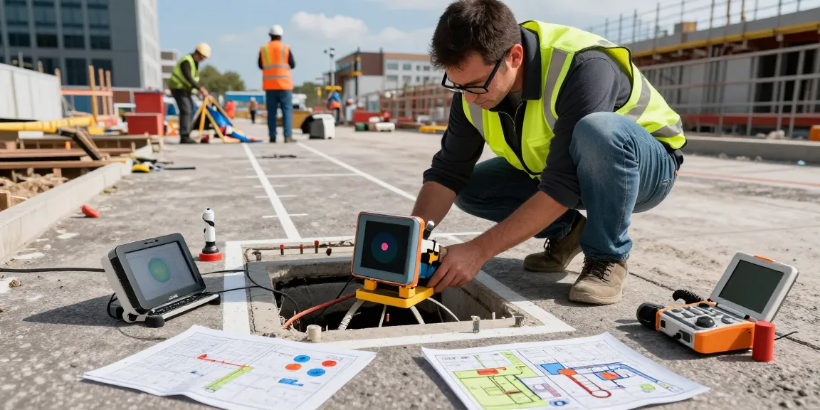
Geophysical Survey Methods and Tools
The geophysical survey is where GPR technology is employed. Surveyors navigate the site with sophisticated GPR equipment, such as the Leica DS2000 or IDS Detector Duo. These systems emit radar waves into the ground, and the reflected signals are captured to develop an image of the underground utilities. This data is then processed to produce detailed maps of the subsurface environment.
Practical Applications of GPR Utility Surveys
Case Studies in Urban Development
The application of GPR utility surveys is notably visible in urban development projects. For instance, in Camden, London, a comprehensive GPR survey was conducted prior to a major construction project. The survey revealed complex networks of utilities, allowing project managers to adjust their plans and avoid potential utility strikes, thereby ensuring safety and operational efficiency.
Impact on Construction Planning and Safety
By providing precise locations of buried utilities, GPR surveys significantly impact construction safety. This foresight helps prevent costly delays and accidents associated with hitting hidden utilities during excavation, thus enabling smoother workflow on construction sites.
Utilizing GPR Data for Effective Decision Making
The data produced from GPR surveys enhances decision-making processes. Engineers and planners can rely on accurate and detailed maps of subsurface utilities, thus making informed choices about infrastructure development and maintenance. This reliability diminishes risks while enhancing productivity within construction timelines.
Challenges and Solutions in Utility Surveying
Common Obstacles Faced During Surveys
Despite advancements in GPR technology, several challenges persist in utility surveying. Factors such as dense urban environments, varying soil compositions, or interference from other buried materials can complicate the accuracy of GPR surveys. Additionally, limitations in the equipment’s penetration depth can hinder the detection of deeper utilities.
Best Practices for Accurate Utility Detection
To overcome these challenges, implementing best practices is crucial:
- Comprehensive Planning: Prior to carrying out the survey, comprehensive planning should be executed, including a thorough review of existing utility maps and records.
- Utilisation of Advanced Tools: Employing the latest GPR technology and tools will enhance data accuracy and the efficiency of utility detection.
- Expert Interpretation: Skilled personnel should interpret the GPR data, as proficiency is critical in differentiating between actual utilities and background noise in the data.
Future Technologies in Underground Mapping
The field is continually evolving, with emerging technologies promising to enhance underground mapping. Innovations such as 3D GPR modelling and integration of artificial intelligence into data analysis are expected to transform utility surveying, making it more accurate and user-friendly.
Future Trends in GPR Utility Surveys
Anticipated Developments for 2026
As we look towards 2026, several developments are anticipated to shape the future of GPR utility surveys. The integration of real-time data processing capabilities, coupled with mobile GPR systems, will allow for more dynamic and versatile surveying techniques. This evolution will promote efficiency and reduce operational costs for firms engaging in utility mapping.
The Role of Innovation in Surveying Techniques
Continuous innovation in surveying techniques is vital for the GPR sector. Adopting technologies like drone-assisted GPR surveys could provide even greater accessibility to remote or challenging terrains, offering significant advantages in surveying previously hard-to-reach areas.
Environmental Considerations and Sustainability
As environmental concerns grow, the demand for sustainable practices within surveying is also increasing. Future GPR technologies will likely focus on minimising environmental impact during surveys, employing eco-friendly methods to conduct utility mapping without disturbing the surrounding ecosystem.
What are GPR Utility Surveys PAS128 London?
GPR Utility Surveys that comply with the PAS128 standard are crucial for ensuring safety and efficacy when working in urban areas rich with existing utilities. This systematic approach ensures that all buried services are accurately located and documented prior to any excavation.
Why is GPR Important in Utility Surveys?
Ground Penetrating Radar technology serves as the backbone of modern utility surveying. Its ability to provide a non-destructive, real-time view of underground conditions makes GPR indispensable for construction and infrastructure projects, thus mitigating risks associated with utility strikes.
What challenges do GPR surveys face?
GPR surveys face several challenges including interference from surrounding materials, signal attenuation in various soil types, and the complexities associated with dense urban environments. Addressing these hurdles requires advanced technologies and expert interpretation.
How do GPR surveys improve safety during excavation?
By accurately mapping underground utilities, GPR surveys provide essential information that enhances safety during excavation. This foresight helps prevent accidents, costly damages, and project delays, thereby ensuring a safer work environment.
What is the cost of GPR Utility Surveys PAS128 London?
The cost of GPR Utility Surveys can vary based on several factors including the complexity of the site, the extent of coverage required, and the types of utilities involved. However, the investment is often justified by the substantial savings incurred from avoiding utility strikes and subsequent project delays.